


GPSMAP® 86i Garmin InReach Maritime Navigation
Last items in stock
Always connected with the GPSMAP 86i Maritime handheld with inReach features
Robust, simple and safe
The GPSMAP 86i is a marine version of the popular GPSMAP 66i. Both combine GPS navigation with Garmin inReach technology. However, the GPSMAP 86i has a slightly larger housing than the GPSMAP 66i, making it floatable. In addition, the GPSMAP 86i can read the latest G3 Bluechart charts (These charts provide industry-leading coverage and detail at sea) and allows connectivity to certain marine peripheral devices. Both units have the battery permanently installed.
An active satellite subscription is required to connect the GPSMAP 86i to the Iridium network (for transmission of tracking data and SMS). Depending on the frequency of use, there are different models, from flexible monthly packages to an annual contract.
Set sail with confidence with the GPSMAP 86i Maritime
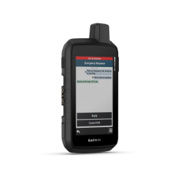
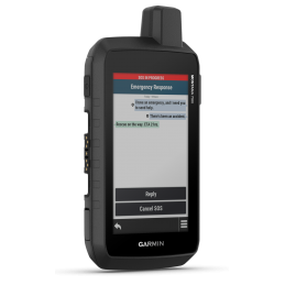
Satellite Communications
Stay connected globally with GPSMAP® 86i thanks to built-in inReach satellite technology and additional service options. Send and receive two-way text messages, track and share your route, and send an interactive SOS distress call when needed to get help from a 24/7 global monitoring center via the Iridium satellite network with 100% global coverage. Also get weather forecasts right on the device to make informed decisions based on conditions on the ground or at your destination.
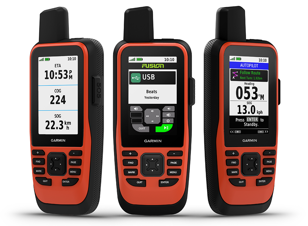
Connect to your boat
Sync the GPSMAP 86i with compatible Garmin chartplotters and instruments to see real-time vessel data right on the handheld. It can also serve as a remote control for convenient operation of your Garmin autopilot and certain FUSION marine products. When you're underway, the customizable GPS filter smooths out speed and heading readings in rough seas to increase tracking accuracy.
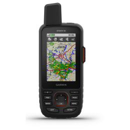
Optional BlueChart g3 charts
A worldwide basemap is preloaded on the GPSMAP 86i Maritime. You can also add BlueChart g3 coastal charts, which provide industry-leading coverage, clarity and detail with integrated data from Garmin and Navionics. Detailed depth contours allow you to see depth contours as shallow as 0.3 meters, more accurately depicting bottom structures. The result is optimized fishing maps and additional detail for marshes, channels and harbor maps.
Always connected
Receive smart notifications directly on the GPSMAP 86i Maritime when paired with your compatible smartphone. You can also sync the GPSMAP 86i with the Garmin Explore portal to manage your favorite waypoints, tracks and routes via the cloud. The GPSMAP 86i supports WLAN, ANT technology and Bluetooth wireless technology so you can easily update and connect wirelessly. The GPSMAP 86i Maritime is preloaded with a built-in lithium battery that provides up to 35 hours of battery life in 10-minute tracking mode.
Details
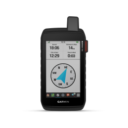
- Water resistant, floatable, easy to read 3 inch display even in sunlight, button operation for easy use on water
- Stream ship data from compatible chartplotters and instruments to consolidate your marine system information
- Always in conjunction with inReach satellite communications and two-way text messaging over the Iridium satellite network with 100% global coverage (satellite subscription required).
- Serves as a remote control for convenient operation of your Garmin autopilot and certain FUSION marine products
- Supports optional BlueChart g3 charts
- Customizable GPS filter for smoothing speed and heading displays in sea conditions

Specific References
Related products
Always connected with the GPSMAP 86i Maritime handheld with inReach features
Robust, simple and safe
The GPSMAP 86i is a marine version of the popular GPSMAP 66i. Both combine GPS navigation with Garmin inReach technology. However, the GPSMAP 86i has a slightly larger housing than the GPSMAP 66i, making it floatable. In addition, the GPSMAP 86i can read the latest G3 Bluechart charts (These charts provide industry-leading coverage and detail at sea) and allows connectivity to certain marine peripheral devices. Both units have the battery permanently installed.
An active satellite subscription is required to connect the GPSMAP 86i to the Iridium network (for transmission of tracking data and SMS). Depending on the frequency of use, there are different models, from flexible monthly packages to an annual contract.